The UK’s mountainous regions harbour dozens of pristine alpine lakes that remain largely unknown to casual hikers. These hidden gems offer crystal-clear waters surrounded by dramatic peaks, providing some of the most rewarding hiking experiences in Britain.
Seven remarkable alpine lakes across Scotland, the Lake District, and Snowdonia offer secluded hiking adventures that rival any European mountain destination. Each location requires specific preparation and navigation skills, but rewards visitors with untouched natural beauty and peaceful solitude.
From remote Scottish corries to forgotten tarns tucked beneath Welsh peaks, these alpine lakes showcase Britain’s wild side. The routes range from challenging mountain ascents to moderate walks, each offering unique geological features and wildlife spotting opportunities that make the journey worthwhile.
What Makes Alpine Lakes Unique in the UK?
UK alpine lakes form through distinct glacial processes and exist within specific elevation zones that create unique ecological conditions. These water bodies face particular accessibility challenges due to their remote locations and Britain’s variable weather patterns.
Distinctive Geological Features
UK alpine lakes occupy corries and tarns carved by glacial activity during the last Ice Age. These circular depressions, known as cirques, contain water bodies that typically sit above 300 metres elevation in Scotland and Wales.
The bedrock composition varies significantly between regions. Scottish Highland lakes rest on ancient Lewisian gneiss and Dalradian schists. Welsh alpine lakes form within Ordovician and Cambrian volcanic rocks.
Glacial moraines often dam these lakes naturally. Terminal moraines create barriers that trap meltwater and precipitation. This process formed many of the UK’s highest altitude permanent water bodies.
The lakes maintain consistent cold temperatures year-round. Surface temperatures rarely exceed 15°C even during summer months. Winter ice formation occurs regularly above 400 metres elevation.
Microclimates and Ecosystems
Alpine lakes in the UK support oligotrophic ecosystems with low nutrient levels and high water clarity. These conditions favour specialised plant and animal communities adapted to cold, nutrient-poor environments.
Arctic char populations exist in several Scottish and Welsh alpine lakes. These fish represent relict populations from post-glacial periods. They require water temperatures below 20°C and high oxygen levels.
Surrounding vegetation includes alpine sedges, mountain sorrel, and moss campion. These plants tolerate extreme temperature fluctuations and short growing seasons. Many species flower only during brief summer periods.
The lakes experience temperature inversions where warmer air sits above cold water surfaces. This creates localised weather patterns distinct from surrounding areas. Morning mists and sudden temperature drops occur frequently.
Limitations and Accessibility
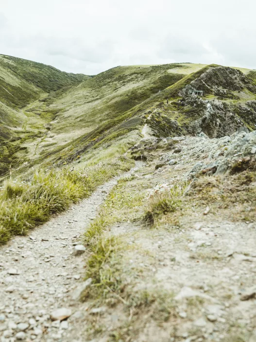
Most UK alpine lakes require 2-4 hour walks across rough terrain to reach. Paths often involve boulder fields, steep ascents, and unmarked routes. Navigation skills and proper equipment are essential.
Weather conditions change rapidly at altitude. Visibility can drop to less than 10 metres within minutes. Temperature differences of 10-15°C between valley floors and lake elevations are common.
Access restrictions apply to some locations during bird nesting seasons from April to July. Military training areas in parts of Scotland and Wales may limit access at certain times.
Seasonal accessibility varies significantly. Snow cover can persist until May or June at higher elevations. Ice formation makes some lakes dangerous to approach during winter months.
How to Prepare for Hidden Alpine Lake Hikes
Alpine lake hikes require specific preparation beyond standard walking routes. Proper gear, navigation skills, and environmental awareness ensure safe access to these remote destinations.
Essential Gear Checklist
Navigation Equipment
- OS Landranger or Explorer maps (1:25,000 scale)
- Compass with adjustable declination
- GPS device or smartphone with offline maps
- Emergency whistle
Clothing and Protection
Layered clothing systems work best for changing mountain conditions. Base layers should wick moisture whilst mid-layers provide insulation. Waterproof jackets and overtrousers protect against sudden weather changes.
Footwear and Safety
Sturdy hiking boots with ankle support prevent injuries on rocky terrain. Gaiters keep debris out of boots. Carry a basic first aid kit including blister plasters, antiseptic wipes, and pain relief medication.
| Essential Items | Purpose |
|---|---|
| Head torch | Early starts/late returns |
| Emergency shelter | Weather protection |
| Water purification tablets | Lake water treatment |
| High-energy snacks | Sustained energy |
Navigation Skills and Safety
Map Reading Fundamentals
Learn to identify contour lines, grid references, and terrain features before attempting remote routes. Practice taking compass bearings and triangulating position using visible landmarks.
Weather Awareness
Check mountain weather forecasts 24 hours before departure. Conditions change rapidly above 500 metres elevation. Cloud can obscure paths and landmarks within minutes.
Emergency Procedures
Inform someone of your planned route and expected return time. Carry emergency contact details and know how to call mountain rescue (999 or 112). The what3words app provides precise location sharing for emergencies.
Mobile phone coverage remains patchy in mountain areas. Don’t rely solely on smartphone navigation apps.
Environmental Responsibility
Leave No Trace Principles
Pack out all rubbish including food waste and toilet paper. Bury human waste at least 60 metres from water sources and 15 centimetres deep. Use established campsites where wild camping is permitted.
Wildlife Protection
Keep dogs on leads near nesting birds, particularly during breeding season (March to August). Avoid disturbing wildlife or vegetation around lake edges where rare plants may grow.
Water Source Protection
Never wash directly in alpine lakes or streams. Use biodegradable soap at least 60 metres from water sources. Avoid using lakes as water sources immediately downstream from livestock grazing areas.
Access Rights
Respect private land boundaries and seasonal restrictions. Some areas restrict access during lambing season or grouse shooting periods. Check local authority websites for current access information.
Top 7 Hidden Alpine Lakes in the UK for Unforgettable Hikes
These carefully selected mountain lakes offer pristine wilderness experiences away from crowded tourist routes. Proper preparation and understanding of access requirements ensure safe and rewarding adventures.
Criteria for Selecting Hidden Alpine Lakes
The selection process focuses on remote locations that require genuine hiking effort to reach. These lakes sit at elevations above 300 metres in mountainous terrain with limited visitor numbers.
Accessibility standards determine inclusion based on moderate to challenging hiking difficulty. Each lake requires at least 2-3 hours of walking from the nearest road access point.
Water clarity and mountain setting form essential criteria. The lakes feature clear alpine water surrounded by peaks, crags, or high moorland typical of UK mountain environments.
Limited public awareness ensures these destinations remain relatively unknown. Local hiking groups and experienced walkers know these spots, but they rarely appear in mainstream guidebooks.
The lakes span across Scotland’s Highlands, the Lake District, and Welsh mountains. Each offers unique geological features, from glacial tarns to reservoir-fed mountain pools.
Planning Your Adventure
Essential gear includes waterproof clothing, sturdy hiking boots, and navigation equipment. Weather conditions change rapidly at altitude, requiring layers and emergency shelter.
Route planning demands detailed OS maps and compass skills. Mobile phone coverage remains unreliable in these remote areas, making traditional navigation methods crucial.
Seasonal considerations affect accessibility throughout the year. Spring offers clear views but muddy paths, whilst autumn provides stable weather before winter snow.
Safety protocols require informing others of planned routes and expected return times. Solo hikers should carry emergency communication devices and first aid supplies.
Leave no trace principles protect these fragile environments. Hikers must pack out all waste and avoid camping near water sources to preserve water quality.
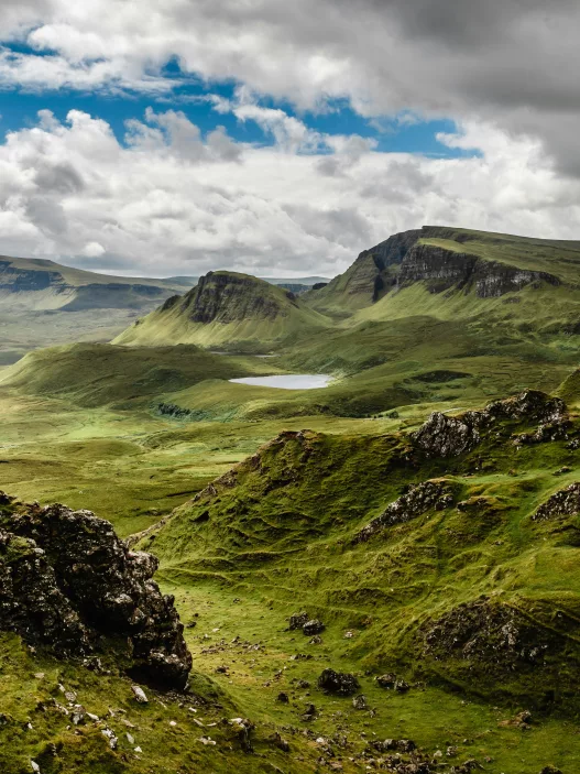
Spectacular Trails in Scotland
Scotland’s remote highlands conceal pristine alpine lakes accessible only through challenging mountain routes. These lochs demand serious navigation skills and mountaineering experience due to their isolated positions above 600 metres elevation.
Lochan a’ Choire Fionn – Remote Wilderness
This hidden gem sits at 720 metres elevation in the Cairngorm National Park’s most isolated section. The lochan requires a demanding 8-kilometre approach through unmarked terrain.
Route Details:
- Starting Point: Linn of Dee car park
- Distance: 16km return
- Elevation Gain: 450m
- Difficulty: Grade 3 scrambling required
The trail begins along the Lui Water before ascending steep scree slopes. Hikers must navigate using compass and map as no waymarkers exist beyond the first 2 kilometres.
Weather conditions change rapidly at this elevation. Snow patches persist until July most years, creating treacherous conditions on approach slopes.
The lochan itself spans 200 metres across crystal-clear water. Granite cliffs rise 150 metres directly from the water’s edge, creating dramatic reflections on calm days.
Lochan nam Breac – Rugged Highland Beauty
Located in the remote Knoydart Peninsula, this alpine lake sits at 580 metres above sea level. Access requires either a 22-kilometre hike or boat transport to Inverie village.
The most practical route starts from Kinloch Hourn, following ancient stalkers’ paths through Glen Barrisdale. Hikers face river crossings that become impassable during heavy rain.
Key Features:
- Depth: 15 metres maximum
- Surrounding Peaks: Sgurr na Ciche (1,040m), Garbh Chioch Mhor (1,013m)
- Wildlife: Red deer, golden eagles, wildcats
The final ascent involves scrambling across loose rock for 300 metres. Mountain rescue services operate limited coverage in this area, making self-sufficiency essential.
Rainbow trout inhabit the lochan’s depths, though fishing requires landowner permission. The water maintains 4°C temperature year-round due to underground springs.
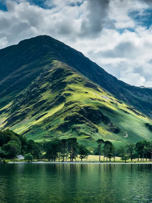
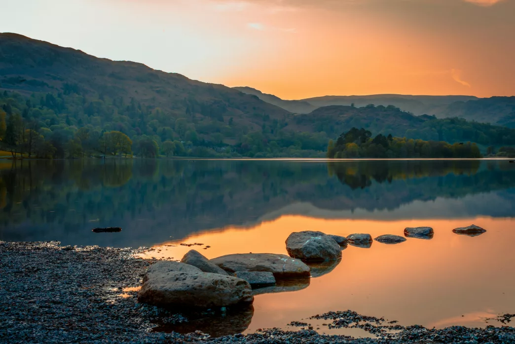
Secret Gems in the Lake District
The Lake District hides two remarkable alpine lakes that escape most hikers’ attention. Blea Water sits beneath towering crags accessible only via steep terrain, whilst Foxes Tarn holds the distinction of being England’s smallest alpine lake.
Blea Water – Steep Escarpment Hike
Blea Water nestles beneath the dramatic eastern face of High Street, surrounded by some of the Lake District’s most imposing crags. This remote tarn requires a challenging ascent via the Rough Crag path from Mardale Head.
The 2.5-mile approach involves 600 metres of elevation gain through increasingly rugged terrain. Hikers must navigate loose scree and exposed rock sections during the final ascent.
Key features:
- Elevation: 488 metres above sea level
- Depth: Over 63 metres (Lake District’s deepest tarn)
- Surrounding peaks: High Street, Mardale Ill Bell, Harter Fell
The tarn’s crystal-clear waters reflect the surrounding precipitous cliffs. Red deer frequently graze the surrounding fells, particularly during early morning hours.
Access requires good weather conditions and proper hiking boots. The path becomes treacherous in wet conditions due to exposed rock slabs.
Foxes Tarn – England’s Smallest Alpine Lake
Foxes Tarn claims the title of England’s smallest alpine lake, measuring just 25 metres across. This hidden gem sits at 550 metres elevation between Scafell Pike and Scafell, accessible via the challenging Foxes Tarn path.
The 1.8-mile route from Wasdale Head involves 520 metres of ascent through boulder fields and steep grass slopes. Hikers encounter multiple stream crossings and loose rock sections.
Tarn specifications:
- Surface area: 491 square metres
- Maximum depth: 3.7 metres
- Water temperature: Rarely exceeds 8°C
The tarn’s small size creates an intimate alpine atmosphere. Surrounding crags provide shelter from prevailing winds, creating surprisingly calm conditions even during stormy weather.
Ravens and peregrine falcons nest in nearby cliff faces. The tarn often freezes completely during winter months, creating distinctive ice formations.
Undiscovered Alpine Lakes in Snowdonia
Snowdonia contains several pristine alpine lakes that remain largely unknown to mainstream hikers. Llyn Glas offers peaceful mountain scenery accessible via lesser-known paths, whilst Llyn Du’r Arddu provides dramatic views beneath towering cliff faces.
Llyn Glas – Tranquil Mountain Retreat
Llyn Glas sits nestled between Glyder Fach and Glyder Fawr at approximately 600 metres elevation. The lake remains hidden from most walkers who typically follow the main Glyder ridge path.
Access requires a 2.5-hour trek starting from Pen-y-Pass car park. The route follows the Miners’ Track initially before branching left towards Llyn Caseg-fraith.
Key Features:
- Crystal-clear water reflecting surrounding peaks
- Rocky shoreline ideal for rest stops
- Minimal visitor numbers throughout the year
The path becomes indistinct after leaving the main track. Navigation skills are essential, particularly in poor weather conditions.
Wild camping is possible near the eastern shore, though permits are not required. The area offers excellent photography opportunities during golden hour.
Llyn Du’r Arddu – Dramatic Cliffside Waters
Llyn Du’r Arddu lies beneath the imposing north face of Snowdon at 580 metres altitude. The lake’s dark waters reflect the dramatic cliff formations above, creating an atmospheric mountain scene.
The approach begins from Llanberis Pass, following a boggy path for approximately 45 minutes. The route crosses rough terrain and requires sturdy walking boots.
Access Details:
- Distance: 3.2km return
- Elevation gain: 280m
- Difficulty: Moderate
The lake sits directly below some of Wales’ most challenging rock climbs. Climbers frequently use the area, particularly during summer months.
Winter conditions can make access treacherous due to ice formation on the approach path. The lake occasionally freezes completely during severe cold spells.
Responsible Travel and Lake Conservation
Alpine lakes remain fragile ecosystems that require careful protection from increasing visitor numbers. Hikers can preserve these pristine waters through mindful practices and supporting conservation efforts.
Minimising Your Impact
Leave No Trace principles form the foundation of responsible lake visits. Visitors should pack out all rubbish, including food scraps and tissues that attract wildlife.
Camping regulations vary by location. Wild camping is permitted in Scotland under the Right to Roam Act, but hikers must pitch tents at least 100 metres from water sources.
Water contamination prevention requires specific actions:
- Use biodegradable soap 200 metres from lakes
- Dispose of greywater away from watersheds
- Avoid washing directly in alpine waters
Footpath erosion damages surrounding vegetation. Hikers should stick to established trails and avoid creating shortcuts across sensitive areas.
Wildlife protection means storing food securely and observing animals from distance. Feeding birds or fish disrupts natural feeding patterns and water quality.
Supporting Local Initiatives
Mountain rescue teams across the UK operate through donations and volunteer support. The Lake District Mountain Rescue Association and Scottish Mountain Rescue coordinate emergency services for remote areas.
Local conservation groups manage specific threats to alpine environments. The Cairngorms National Park Authority runs water quality monitoring programmes that visitors can support through citizen science projects.
Sustainable accommodation choices include YHA hostels and eco-certified B&Bs near trailheads. These businesses often contribute directly to local conservation funding.
Transport decisions affect carbon footprints significantly. Public transport reaches many alpine areas, including the West Highland Line to Corrour Station and bus services to Snowdonia car parks.
Visitor centre donations fund habitat restoration projects. The John Muir Trust and National Trust operate specific programmes protecting high-altitude lake ecosystems through membership contributions.
Planning Your Next Hidden Alpine Adventure
Essential kit includes waterproof boots, weatherproof clothing, and navigation tools. A detailed OS map and compass remain crucial for remote locations.
Weather conditions change rapidly in alpine environments. Check forecasts before departure and prepare for sudden temperature drops.
Most hidden lake hikes require moderate to advanced fitness levels. Routes typically involve steep ascents and uneven terrain lasting 4-8 hours.
Best hiking months span May through September when paths remain accessible. Winter conditions make many routes dangerous or impassable.
| Season | Conditions | Difficulty |
|---|---|---|
| Spring | Muddy paths, unpredictable weather | Moderate |
| Summer | Clear trails, longer daylight | Easier |
| Autumn | Slippery leaves, shorter days | Moderate |
Transport planning proves essential as many trailheads lack regular public transport. Car hire or taxi services may be necessary for remote starting points.
Emergency preparations must include first aid supplies and emergency shelter. Mobile phone coverage remains patchy in mountainous areas.
Park rangers and local hiking groups provide current trail conditions. Contact visitor centres before attempting less-travelled routes.
Accommodation booking requires advance planning during peak season. Mountain huts, B&Bs, and campsites fill quickly between June and August.
Group hiking offers increased safety for challenging routes. Solo hikers should inform others of their planned route and expected return time.
Photography equipment benefits from protective cases due to spray from waterfalls and lakes. Early morning light provides optimal conditions for alpine photography.
Frequently Asked Questions
These questions address the most practical concerns for hikers seeking challenging routes to remote alpine lakes. The answers focus on safety considerations, preparation requirements, and specific recommendations for different experience levels.
What are the top recommended hidden hikes in the Lake District for experienced walkers?
The ascent to Angle Tarn via the Rossett Pike route offers experienced hikers a demanding climb with stunning alpine scenery. This challenging path requires navigation skills and takes approximately 6-8 hours to complete.
Stickle Tarn approached from the less-travelled eastern route provides a rigorous alternative to the popular tourist path. The terrain demands proper mountain boots and experience with steep, rocky sections.
Red Tarn beneath Helvellyn can be reached via the remote Glenridding Dodd approach. This route involves exposed scrambling sections and requires confidence in changeable weather conditions.
Can you provide a guide to multi-day treks in the Lake District featuring secluded alpine lakes?
The Fairfield Horseshoe extended route allows hikers to visit multiple tarns over two days with overnight camping at designated areas. Wild camping requires landowner permission and adherence to Leave No Trace principles.
A three-day circuit combining Grasmere, Easedale Tarn, and Codale Tarn offers varied terrain and accommodation options in nearby villages. Each day covers 12-15 kilometres with significant elevation gains.
The Langdale to Borrowdale traverse spans two days and includes visits to Stickle Tarn and Sprinkling Tarn. Hikers must book accommodation in advance during peak seasons.
Which hidden alpine lake walks in the Lake District are suitable for solo hikers prioritising safety?
Tarn Hows via the lesser-known northern approach provides excellent mobile phone coverage and regular foot traffic for safety. The well-maintained path reduces risks associated with navigation errors.
Loughrigg Tarn offers a moderately challenging route with multiple escape routes and proximity to main roads. Solo hikers can complete this walk in 3-4 hours with minimal technical difficulty.
Elter Water accessed through the quiet Skelwith Bridge route maintains good visibility and established footpaths. The circular walk allows hikers to return via alternative routes if conditions deteriorate.
Are there any lesser-known Lake District hikes that offer views comparable to the Helvellyn ridge?
The Crinkle Crags eastern approach provides dramatic ridge walking with panoramic views rivalling Helvellyn’s famous vistas. This route attracts fewer crowds whilst maintaining similar scenic quality.
High Street accessed via the Mardale Head path offers extensive ridge walking with views across multiple valleys. The Roman road provides historical interest alongside spectacular alpine scenery.
Blencathra’s Sharp Edge presents technical scrambling challenges with rewards matching Helvellyn’s Striding Edge. The approach requires good weather conditions and scrambling experience.
What are some of the Lake District’s hidden gems for hikers looking to avoid the crowds?
Burnmoor Tarn near Wasdale receives minimal visitor traffic despite offering excellent mountain views. The remote location requires a 4-hour circular walk from the nearest car park.
Seathwaite Tarn in Duddon Valley provides solitude and fishing opportunities away from popular tourist routes. The gentle approach makes it accessible whilst maintaining its hidden character.
Devoke Water represents the Lake District’s largest natural tarn with virtually no tourist presence. The moorland setting offers unique landscape views different from typical fell walks.
How do I prepare for a challenging hike in the more remote areas of the Lake District?
Essential equipment includes waterproof clothing, navigation tools, first aid supplies, and emergency shelter. Hikers should carry extra food and water beyond their calculated requirements.
Weather forecasting becomes critical for remote area safety, with conditions changing rapidly at altitude. Mountain weather services provide specific forecasts for fell walking conditions.
Route planning must include escape routes and emergency contact procedures. Hikers should inform others of their intended route and expected return times before departure.